Enregistrez gratuitement cette image
en 800 pixels pour usage maquette
(click droit, Enregistrer l'image sous...)
|
|
Réf : T01280
Thème :
Terre vue de l'espace - Iles - Récifs (286 images)
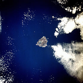
Titre : Ascension Island, Atlantic Ocean December 1990
Description : (La description de cette image n'existe qu'en anglais)
Located in the middle of the south Atlantic Ocean, Ascension Island (latitude 8 degrees south) is one of the few surface manifestations of the Mid-Atlantic Ridge. A British possession populated by fewer than 1000, this small volcanic island measures approximately 9 miles (14 kilometers) in length and 6 miles (10 kilometers) in width. The highest point on the island, Green Mountain, which reaches 2817 feet (860 meters) above sea level, is an extinct volcanic crater located near the southeast coast. Georgetown, the only settlement, is on the west side of the island. Ascension was discovered by Portuguese navigator Joao da Nova on Ascension Day 1501, thereby providing the island its name. American engineers constructed an airfield on the island’s southwest side during World War II, and the facility was used as a refueling base for selected transatlantic flights.
|
|

